Migration from Topography
The traditional approach to handling data taken in areas of extreme (or even modest) topography is to statically correct the data to some datum, and then migrate as if the source and receivers were on the usually absolutely flat plane. It is quite easy to perform the migration directly from the topography. The major difficulty is not in making the algorithm handle the topography, but, instead, the difficulty arises in having accurate topographic data available and in being able to estimate an accurate near surface velocity field. What this section shows is that migrating from topography is not an issue.
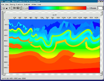
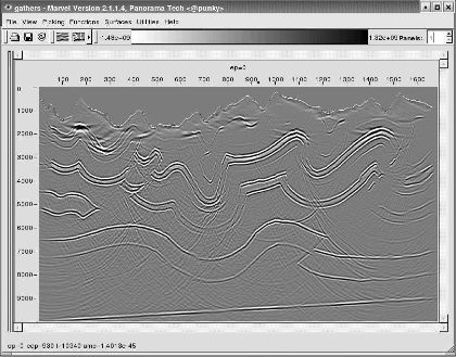
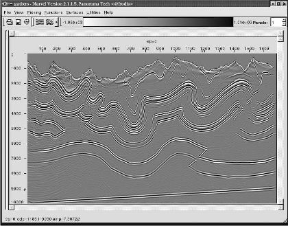
Migration from topography requires the exact specification of the location and elevation of each and every source and receiver in the acquisition. Even though this information is routinely available, it is frequently not stored concomitant with the data, or it is lost after static corrections. Implementation of migration from topography requires only that wavefields be generated at the source or back-propagated from the receiver locations and elevations. Part (a) of Figure 9 shows a relatively simple model with relatively complex topography. Parts (b) and (c) show Kirchhoff and two-way images of these data. Visual comparison suggests that, again, the two-way approach is vastly superior to the Kirchhoff method.
(a)
The
BP
(AMOCO)
Canadian
foothills
topographic
model
(b)
Kirchhoff
migration
of
the
BP
tomographic
data
|
- Introduction
- Seismic Modeling
- History
- Zero Offset Migration Algorithms
- Exploding Reflector Examples
- Prestack Migration
- Prestack Migration Examples
- Common Azimuth on the SEG/EAGE C3-NA Synthetic
- Kirchhoff versus One-Way on a Gulf of Mexico 2D Salt Synthetic
- A North Sea Sill Synthetic
- Marmousi Case Study
- An Imaging Note and the BP 2.5 Dimensional Data
- BP 2.5 D Data
- BP 2004 Salt Structure Data
- SEG AA' Data Set
- Migration from Topography
- The SMAART JV Sigsbee Model
- SMAART JV Pluto Data Set
- SEG/EAGE C3-NA Data Imaging
- Anisotropic Earth Models
- Data Acquisition
- Migration Summary
- Isotropic Velocity Analysis
- Anisotropic Velocity Analysis
- Case Studies
- Course Summary