1923-1935
Paraphrasing Peterson and Waller 1974 () :
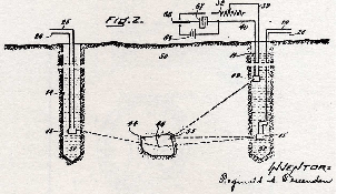
In 1924 a Mintrop seismic refraction crew, engaged by Gulf Production Company, successfully located the Orchard salt dome in Fort Bend County, Texas. This was probably the first seismic discovery on the Gulf Coast and maybe the first in the world 1947 (). In 1925, Geophysical Research Corporation (GRC), a wholly owned subsidiary of Amerada Petroleum Corporation, initiated a program in Tulsa, Oklahoma, for the design and construction of new and improved seismograph instrumentation. This instrument was to be based at least in part on the 1917 patent of Reginald Fessenden, who in 1914 built reflection sonic equipment which was able to locate icebergs off the Newfoundland Banks at a distance of two and one-half miles. The 1917 patent "Methods and Apparatus for Locating Ore Bodies," made claims which covered both refraction and reflection methods to be used to locate geologic formations. Figure 6 below is an illustration from the patent (After 1974 ()).
Note that this instrument did not use dynamite. It used a vibrating source! This kind of source was to influence the development of sonars in anti-submarine warfare in the second world war and thus provide a dynamic link between underwater acoustics and surface related seismic acquisition. M. O. Frijink was kind enough to point out to me that B. McCollum and J. G. Karchner received a January 1919 (1982 () Chapter 2) patent for "determining the contour of subsurface strata " that was inspired by their work on detection of the blast waves of artillery during WWI. They did their first field tests in 1921 which supposedly culminated in the first cross sections.
The founders of GRC apparently included DeGoyler and at least as far as the author can determine, Cecil Green. Not a bad crew to have manage the development and testing of sound ranging equipment for the express purpose of finding commercial quantities of subsurface hydrocarbons.
One other scientist of note, also of GRC, was Dr. L. Y. Faust 1942 (). While he did publish in Geophysics, many of his contributions at GRC never reached the light of day.
According to Ed Parma 2004 (), Marland Oil in Ponca City, OK. (the forerunner of CONOCO) claimed to have the first working reflection seismic system in 1927 so its already clear that the race to develop a working reflections seismograph was it full swing. It also remarkable because when the Burbank field came on around 1921, the price of oil at ![]() per barrel and their wasn't a lot of interest in spending money on what was then a truly novel idea.
per barrel and their wasn't a lot of interest in spending money on what was then a truly novel idea.
During the period from 1926-1928, GRC tested their new instruments extensively. Apparently not without creating some doubts and difficulties. From B. B. Weatherby 1945 ()
In early 1929 the method was under considerable fire. Seismic predictions made during 1927 and 1928 had been only partially confirmed by the wells drilled on the Plateau during this period. Doubt was expressed on a number of occasions as to whether the recorded pulses actually were reflections and if so whether they came from beds as deep as the Hunton and Viola. Consequently it was necessary to do something to revive the earlier optimism. Fortunately the opportunity to do this was presented in a program then in progress.
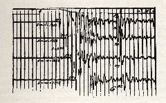
In central Kansas in the spring of 1929 a considerable area had been mapped on the Cimarron anhydrite which varied in depth from three hundred to fifteen hundred feet. An example of the type of record obtained in this work is shown in Figure 7
The record shows a high amplitude reflection arriving approximately two-tenths of a second after the instant detonation of the shot, corresponding to a depth of approximate 730 feet for the reflecting horizon.
It was decided to give the method a thorough checking in this area. First, two core holes a few miles apart were drilled to the Cimarron at locations where the depth was about 500 feet and the relief found in these holes checked with the seismograph. Then in order to prove definitely that these pulses were reflections, a detector was placed in one of the core holes directly on the anhydrite and another detector was placed on the surface as far on one side of the core hole as the shot point was on the other side. It was found that the time of travel of the pulse which had been called the Cimarron reflection, to the detector on the surface was almost exactly twice the time of the first arrival of the wave to the detector in the hole thereby proving that the energy had traveled from the surface to the anhydrite and back to the detector at the surface. To clinch the matter finally it was decided to run a long profile. this was done by placing detectors fifty feet apart along a line through the shot point. Reflections were obtained from the vertical out to a distance of fifteen hundred feet from the shot at a location where the anhydrite was approximately one thousand feet deep. The times of arrival of the pulses were plotted against their respective distance and the resulting curve was the same as the theoretical reflection time distance curve for a section having this velocity. Thus, entirely adequate evidence substantiated the fact that these pulses were actually reflections coming from the Cimarron anhydrite.
By this time many of the difficulties encountered on the Seminole Plateau were being appreciated and some of them were being overcome. Both instruments and shooting technique were being materially improved and the cost of the work reduced. It was still necessary, however, to show that the method was sufficiently dependable to be of commercial importance. Work was resumed and extended on the Seminole Plateau. Although some small degree of success had attended the earlier work, it was not until this later period between 1929 and 1932 that a firm foundation was attained. The striking success of the method in this critical period was of extreme importance. It made the petroleum industry willing to spend vast sums of money on reflection work and through this expenditure further development was greatly accelerated.
For those not familiar with the geology of the Seminole Plateau its important to note that the beds at the depths under investigation are relatively flat. Even in later years, until about 1986, production was from sandstones or cherty limestones and was rarely deeper than a few thousand feet. At this time and in this area, it was probably at best difficult to envision anything remotely resembling what we would call a steeply dipping bed today. Even moderately dipping beds were probably not considered to be an important issue and faults were very likely thought not to produce reflections and so not worthy of consideration in the larger scheme of things. All seismic data was "100%" and typically recorded into less than six phones per shot. Normal Moveout (NMO) correction was nonexistent and velocity estimation was haphazard at best. Interpretation consisted of making maps in the field based on depths calculated using a single or in some case a few spatially varying constant velocities. Geophysicists were full "senior" members of the Flat Earth Society.
|
|---|
|
Fessenden
Figure 6. Fessenden's scheme for locating geologic formations. From his 1917 patent as illustrated in 1974 () |
|
|
|
|---|
|
GRC1929
Figure 7. A 1920's vintage record from the Seminole Plateau 1945 () |
|
|
- Papers
- History of Seismic Migration
- Abstract
- Introduction
- Historical Periods
- 1923-1935
- 1936-1953
- 1954-1959
- 1960-1974
- 1975-1988
- 1989-2004
- Philosophical Ramblings
- Acknowledgments
- Bibliography
- About...
